Volcanoes and Earthquakes: Why the Earth Shakes
In 30 seconds quick read
Volcanoes and earthquakes are two faces of the same phenomenon: the Earth's internal heat moves the tectonic plates, and along their boundaries energy builds up and breaks loose. When rock snaps along a fault, the ground shakes; when magma finds a path to the surface, a volcano erupts. Nobody can predict an earthquake, but scientists can estimate probabilities, engineers can build stronger, and volcanoes can be watched around the clock. Italy lives with both: thousands of small tremors every year, Vesuvius quiet since 1944, and the Campi Flegrei caldera under constant observation.
Key Points
- Volcanoes and earthquakes share one engine: the Earth's internal heat, which moves the tectonic plates a few centimetres per year.
- Earthquakes are born along faults: rock stores elastic energy for decades, then releases it in seconds.
- Volcanoes form wherever magma finds a way up: subduction zones, mid-ocean ridges and hot spots.
- Each extra unit of magnitude means roughly 32 times more energy released.
- Nobody can predict an earthquake: science estimates probabilities, and the real defence is building well.
- Italy is seismic and volcanic ground: in 2025 the INGV located 15,759 earthquakes, almost all too weak to be felt.
Key figures
- 15,759 earthquakes located in Italy in 2025, about one every 33 minutes Source: INGV
- ≈1,350 potentially active volcanoes worldwide, not counting the mid-ocean ridges Source: USGS
- 32× more energy released by an earthquake for each extra unit of magnitude Source: USGS
Deep Dive
The engine is under our feet
Almost everything that moves on the Earth’s surface runs on solar energy: the wind, the rain, the photosynthesis of plants. Volcanoes and earthquakes do not. Their engine sits deep below: the heat trapped inside the planet since its formation, plus the heat produced by radioactive elements decaying in the rock.
Picture the Earth as a pot left to simmer for billions of years. Heat from the core stirs the rock of the mantle with extreme slowness, and the crust acts as the lid. A broken lid, though, cracked into large rigid slabs: the tectonic plates. Dragged along by the mantle’s motion, the plates drift a few centimetres per year.
A practical example: along the San Andreas Fault in California, the two sides slip past each other at an average of 56 millimetres per year (USGS data): roughly the speed at which fingernails grow. It sounds like nothing, but over a million years it adds up to 56 kilometres.
Tremors, eruptions, growing mountain ranges: everything that follows is born of this slow, unstoppable motion.
Three ways plates meet
Nearly all the action happens at plate boundaries, and plates can meet in three ways.
| Boundary | What happens | Example |
|---|---|---|
| Convergent | Plates collide; often one sinks beneath the other (subduction) | The Pacific Ring of Fire |
| Divergent | Plates pull apart and magma rises to fill the gap | The Mid-Atlantic Ridge, which surfaces in Iceland |
| Transform | Plates slide past each other | The San Andreas Fault |
The numbers show how much these boundaries matter: according to the USGS, about 81% of the planet’s largest earthquakes strike along the belt that rings the Pacific, the so-called Ring of Fire, where oceanic plates sink beneath their neighbours. Another 17% or so occur along the belt that runs from Indonesia up through the Himalayas to the Mediterranean.
Italy sits squarely on that second belt. It isn’t bad luck: it’s geography.
Why the ground shakes
Plates do not glide smoothly. Along faults, the great fractures in the rock, friction keeps the two sides locked while the motion continues at depth. The rock bends, loads up like a spring, and stores elastic energy for decades or centuries. Then, in a few seconds, it gives way: the two blocks snap into their new position and the stored energy races out in every direction as seismic waves. That snap is the earthquake.
A practical example: hold a breadstick by its ends and bend it slowly. For a while it flexes, storing energy; then it breaks all at once, with a crack. Rocks along a fault do the same on a scale of kilometres: the bending takes decades, the “crack” a few seconds.
The point at depth where the rock breaks is the hypocentre; the point on the surface directly above it is the epicentre, the one shown on maps. Different waves set out from the rupture: P waves, the fastest, compress the rock in their direction of travel and arrive first; S waves, slower, follow close behind. That is why every earthquake shows a double arrival on a seismograph, like thunder trailing the lightning.
Magnitude and intensity are two different measures
Every earthquake has a single magnitude, which measures the energy released at the source. The scale is logarithmic: one whole unit up means a tenfold larger amplitude on the seismogram and roughly 32 times more energy (USGS). From magnitude 5 to magnitude 7 the energy doesn’t double: it multiplies by about a thousand.
Intensity is something else: it describes the effects at one specific place — how hard the ground shook there, how much damage that town suffered — and it varies with distance from the epicentre and with the type of ground. The same earthquake therefore has a single magnitude but many different intensities.
The most powerful earthquake ever recorded by instruments remains the Chilean event of 22 May 1960: magnitude 9.5.
How a volcano is born
Magma is molten rock, and molten rock is less dense than the solid rock around it: wherever it finds a path, it rises. A volcano is simply the place where that climb reaches the surface.
The paths open up in three settings:
- Subduction zones: the sinking plate releases water, which lowers the melting temperature of the mantle above it. This is how the volcanoes of the Ring of Fire are born, and they are often explosive.
- Mid-ocean ridges: where plates pull apart, magma rises continuously and manufactures new seafloor.
- Hot spots: columns of hot material rising from the deep mantle, even far from any plate boundary. Hawaii, in the middle of the Pacific, was born this way.
How many are there? The USGS counts about 1,350 potentially active volcanoes in the world, not including the submarine chains of the ridges; around 500 of them have erupted in historical time.
Italy, a country that trembles
The Mediterranean is a zone of slow convergence between the African and Eurasian plates: that is why Italy has frequent earthquakes and active volcanoes.
The figures from the INGV, Italy’s National Institute of Geophysics and Volcanology, put things in proportion: in 2025 its monitoring rooms located 15,759 earthquakes in and around Italy, an average of 43 per day, one every 33 minutes. The overwhelming majority pass unnoticed: only one event in ten reached magnitude 2.0, and the strongest of the year, a magnitude 4.8 off the Gargano coast, came nowhere near the threshold of a major earthquake. In other words, the ground in Italy trembles every day, even if we almost never feel it.
Every so often, though, history shows what a fault can do. On 28 December 1908 a magnitude 7.1 earthquake struck the Strait of Messina, in the far south of the country; minutes later a tsunami followed, with waves up to nine and a half metres. The cities of Messina and Reggio Calabria were destroyed and around 80,000 people died: the worst catastrophe the young Italian state, just a few years away from the First World War, had ever faced. Beyond the lives it takes, a great earthquake wipes out homes, roads and factories in seconds: a shock a country pays for over years, visible even in its GDP.
That is why seismic building codes exist: since the shaking cannot be stopped, buildings are designed to withstand it.
Vesuvius and Campi Flegrei, under special watch
Vesuvius has been active for about 40,000 years. In AD 79 one of its eruptions buried Pompeii, Herculaneum and Stabiae; the most recent came in 1944, while the Second World War was being fought across Italy. Since then the volcano has been quiescent: its conduit is blocked by the lavas of that last eruption, seismicity is low and activity is limited to fumaroles. Quiescent, however, does not mean extinct: the INGV’s Vesuvius Observatory watches it continuously, and the alert level (currently green, the lowest) is set by Italy’s Civil Protection on the basis of that data.
Campi Flegrei, just west of Naples, is not a mountain but a caldera, a broad volcanic basin. Its signature is bradyseism: a slow movement of the ground that rises and falls by metres over the centuries. The most elegant proof stands in the columns of the Serapeum, a Roman market hall in Pozzuoli: they are riddled with holes bored by marine molluscs, evidence that the floor once sank below sea level and later re-emerged. In the 1970s and 1980s two bradyseismic crises lifted the ground at Pozzuoli by about 3.5 metres in total, with swarms of earthquakes and damage to buildings; since late 2005 a new phase of uplift has been under way, and 2025 brought the two strongest tremors of the current unrest, both magnitude 4.6 (INGV).
None of this data is a prediction. It says one thing only: the area needs watching with instruments that never switch off — GPS, satellites, seismometers — and that is exactly what happens, around the clock.
No predicting, but preparing
On earthquakes, science is blunt: no one has ever predicted a major earthquake, and the USGS does not expect it to become possible in the foreseeable future. A genuine prediction would have to state the date, the place and the magnitude together; those who claim the skill usually offer statements so vague that some tremor, somewhere, will end up “confirming” them. What can be done is to estimate the probability that an area will be hit within a given number of years, and to use those hazard maps to decide where and how to build.
Volcanoes are easier to observe: before an eruption, moving magma tends to leave measurable traces, which is why seismicity, ground deformation and gases are checked continuously. If something departs from ordinary activity, the alert levels are revised.
The pot below will keep simmering for billions of years to come: understanding how it works is above all a way to be found prepared.
Common myths
-
✗ Myth Earthquakes can be predicted, you just need to watch animals or other warning signs.
✓ Reality No scientist has ever predicted a major earthquake, and the supposed precursors, from odd animal behaviour to swarms of small tremors, are almost never followed by anything. What science can do is estimate probabilities and design buildings that survive the shaking.
-
✗ Myth Beneath the Earth's crust there is an ocean of lava, and volcanoes are its safety valves.
✓ Reality The mantle is solid rock that deforms extremely slowly. Magma only forms where temperature, pressure and water allow it, and it rises because it is less dense than the surrounding rock.
-
✗ Myth Vesuvius is a dead volcano.
✓ Reality It is quiescent, meaning paused: the last eruption was in 1944 and the conduit is blocked by its lavas, but the volcano has been active for about 40,000 years. That is why the INGV monitors it day and night; the alert level today is green.
Mind map
Drag the background to move around and the nodes to reposition them; use − and + to collapse and expand branches.
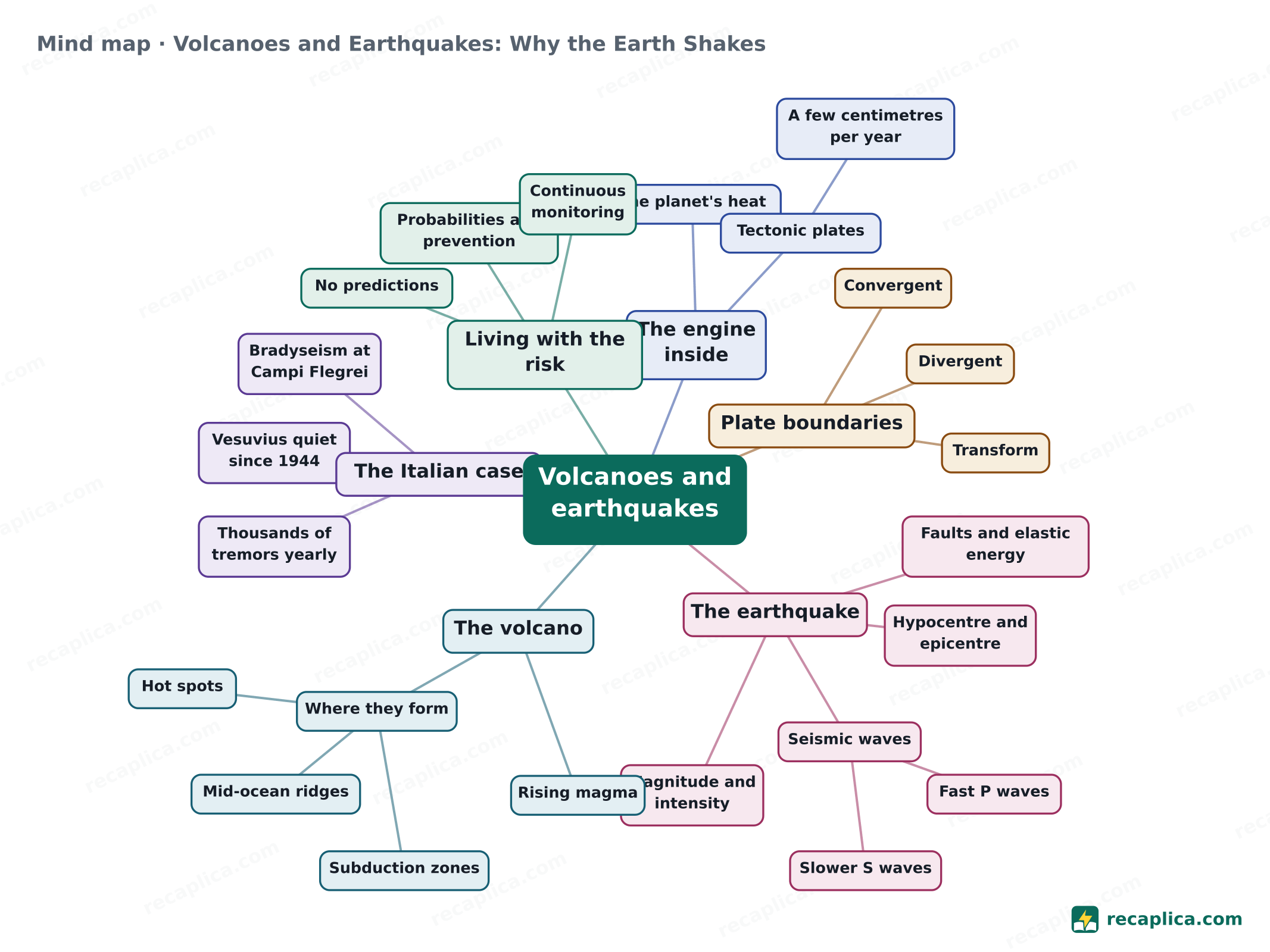
- Volcanoes and earthquakes
- The engine inside
- The planet's heat Left over from its formation, plus radioactive decay.
- Tectonic plates
- A few centimetres per year
- Plate boundaries
- Convergent Plates collide, one sinks beneath the other.
- Divergent Plates pull apart, magma rises.
- Transform Plates slide past each other.
- The earthquake
- Faults and elastic energy
- Hypocentre and epicentre
- Seismic waves
- Fast P waves
- Slower S waves
- Magnitude and intensity
- The volcano
- Rising magma Less dense than rock, it climbs where it can.
- Where they form
- Subduction zones
- Mid-ocean ridges
- Hot spots
- The Italian case
- Thousands of tremors yearly Nearly all imperceptible, located by the INGV.
- Vesuvius quiet since 1944
- Bradyseism at Campi Flegrei
- Living with the risk
- No predictions
- Probabilities and prevention
- Continuous monitoring
- The engine inside
Quiz: test yourself
Answer the questions to check what you have learned: you get instant feedback and a short explanation.
Flashcards
Tap the card to flip it and check whether you remember the answer, then move to the next one.
Explain it in your own words
The ultimate test: if you can explain it in simple words, you've truly understood it. Write your explanation, then compare it with the Recap.
Volcanoes and earthquakes are two faces of the same phenomenon: the Earth's internal heat moves the tectonic plates, and along their boundaries energy builds up and breaks loose. When rock snaps along a fault, the ground shakes; when magma finds a path to the surface, a volcano erupts. Nobody can predict an earthquake, but scientists can estimate probabilities, engineers can build stronger, and volcanoes can be watched around the clock. Italy lives with both: thousands of small tremors every year, Vesuvius quiet since 1944, and the Campi Flegrei caldera under constant observation.
Frequently asked questions
Can earthquakes be predicted?
No. No scientist has ever predicted a major earthquake: a real prediction would have to state the date, the place and the magnitude together. What science can do is estimate the probability that an area will be struck within a given number of years, and that is the basis for building codes and prevention priorities.
Why does Italy have so many earthquakes and volcanoes?
Because the peninsula sits where the African and Eurasian plates slowly converge, on the seismic belt that runs from the Mediterranean to the Himalayas and Indonesia. That is why the INGV, Italy's institute of geophysics and volcanology, locates thousands of tremors every year, nearly all too weak to be felt.
What is the strongest earthquake ever recorded?
The Chilean earthquake of 22 May 1960, magnitude 9.5 (USGS data). Italy's deadliest of the instrumental era remains the 1908 Messina and Reggio Calabria earthquake, magnitude 7.1, which killed around 80,000 people.
Will Vesuvius erupt again?
Vesuvius is quiescent, not extinct: its last eruption was in 1944. Nobody can say when it will erupt again, which is exactly why the INGV monitors it continuously; the alert level, currently green, is updated according to the monitoring data.
What is the difference between magnitude and intensity?
Each earthquake has a single magnitude, which measures the energy released at the source. Intensity describes the effects at a specific place, how hard the ground shook and how much damage was done, and it changes with distance and with the type of ground.